Abstract
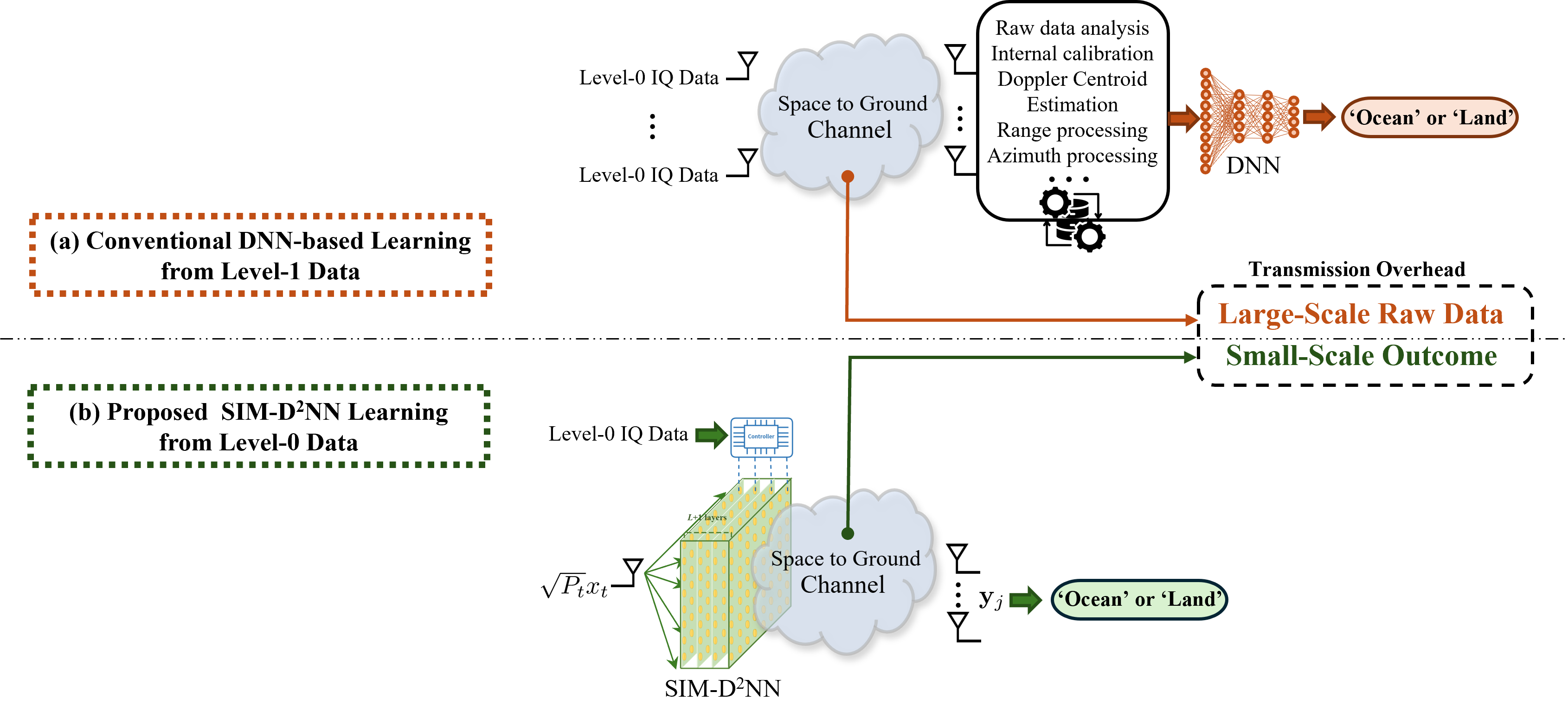
This paper introduces a novel approach for real-time onboard terrain classification from Sentinel-1 (S1) level-0 raw In-phase/Quadrature (IQ) data, leveraging a Stacked Intelligent Metasurface (SIM) to perform inference directly in the analog wave domain. Unlike conventional digital deep neural networks, the proposed multi-layer Diffractive Deep Neural Network (D²NN) setup implements automatic feature extraction as electromagnetic waves propagate through stacked metasurface layers. This design not only reduces reliance on expensive downlink bandwidth and high-power computing at terrestrial stations but also achieves performance levels around 90% directly from the real raw IQ data, in terms of accuracy, precision, recall, and F1 Score. Our method therefore helps bridge the gap between next-generation remote sensing tasks and in-orbit processing needs, paving the way for computationally efficient remote sensing applications.
Project Overview
Space-borne remote sensing missions increasingly rely on Synthetic Aperture Radar (SAR) data to support environmental and societal applications. However, the continuous growth in data volume poses significant challenges in terms of downlink bandwidth, energy consumption, and real-time processing.
Our research introduces a wave-based diffractive deep neural network (D²NN) framework that processes S1 level-0 raw IQ data in orbit, reducing the need for extensive data transmission and computing resources at terrestrial stations. The multi-layer SIM-based approach performs layer-by-layer feature extraction in the electromagnetic domain, achieving higher representational capacity than single-layer systems.
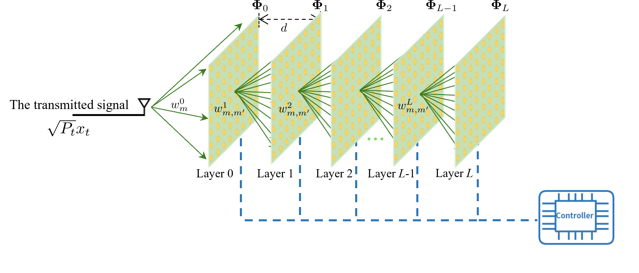
The illustration of the SIM structure and corresponding parameters.
Methodology
Multi-Layer Metasurface Inference
We design a multi-layer SIM-based approach that performs layer-by-layer feature extraction in the electromagnetic domain. By leveraging analog wave propagation and straightforward data augmentation techniques, our method enhances efficiency while reducing computational load and bandwidth requirements.
Enhancement through Data Augmentation
Our research indicates that omitting phase-rotation data augmentation results in a substantial decrease in the F1 Score (from 90.60% to 69.35%). This highlights the essential role of data augmentation strategies in mitigating the inherent noise and Doppler effects in raw level-0 data.
Wave Propagation Model
The model leverages transmission matrices between metasurface layers to enable efficient wave-based computation. The overall propagation matrix facilitates feature extraction as electromagnetic waves propagate through the system, enabling efficient classification without the need for traditional digital processing.
Key Results
| Ablation Setting | Precision (%) | Recall (%) | F1 Score (%) | Overall Accuracy (%) |
|---|---|---|---|---|
| SIM-D²NN (L = 1) | 87.63 | 91.27 | 89.41 | 83.44 |
| SIM-D²NN (L = 6) | 87.21 | 92.87 | 89.95 | 88.15 |
| SIM-D²NN (S = 5%) | 87.84 | 91.49 | 89.62 | 85.75 |
| SIM-D²NN (S = 20%) | 91.56 | 93.98 | 92.76 | 89.31 |
| SIM-D²NN (P_t = 5 dBm) | 86.14 | 92.20 | 89.07 | 80.29 |
| SIM-D²NN (No phase rotation) | 62.09 | 78.54 | 69.35 | 54.97 |
| SIM-D²NN (Baseline) | 90.54 | 90.67 | 90.60 | 87.83 |
| Digital DNN | 94.78 | 97.14 | 95.95 | 92.91 |
Note: Our baseline SIM-D²NN uses L=4 layers, P_t=20 dBm, and S=10%.
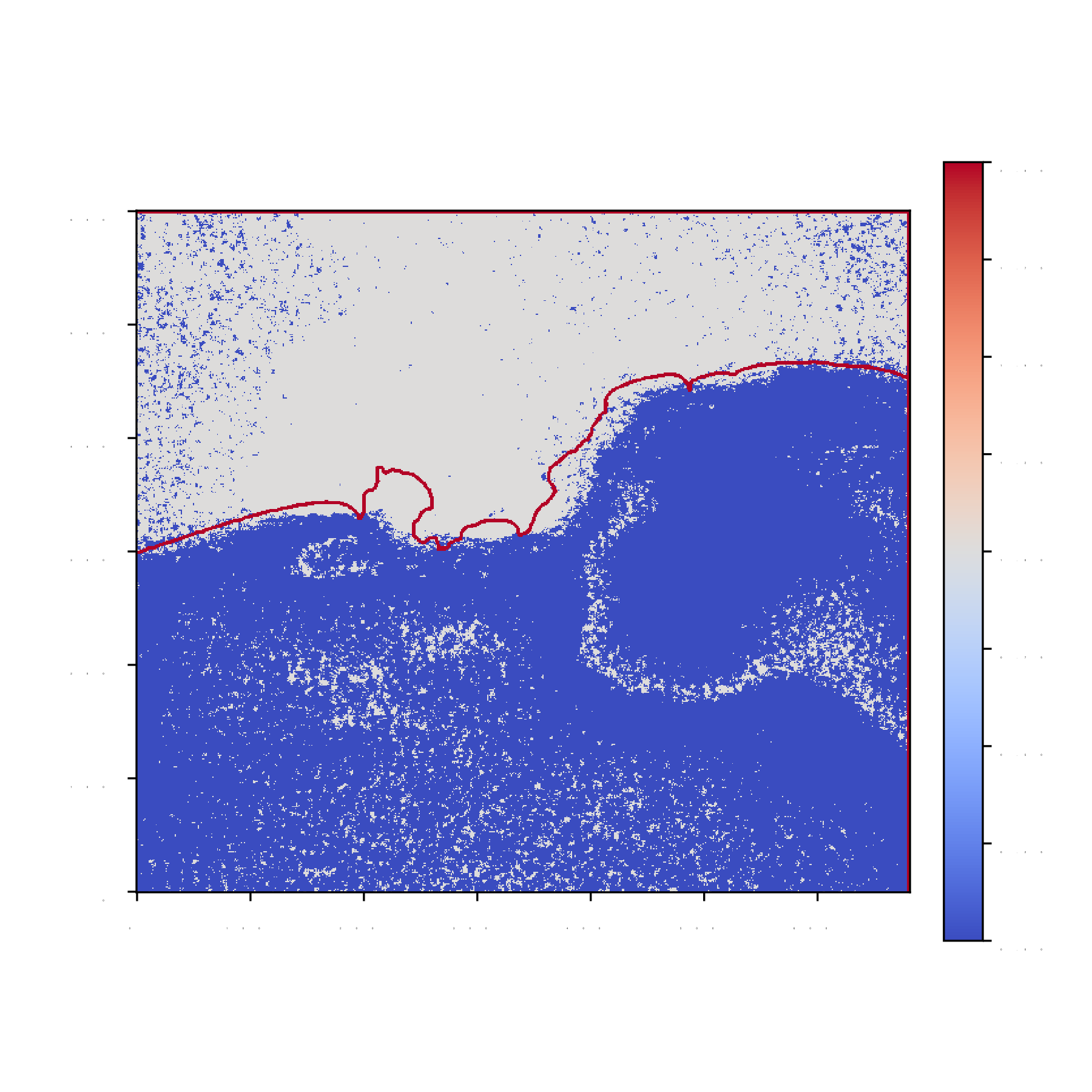
Visualization Results
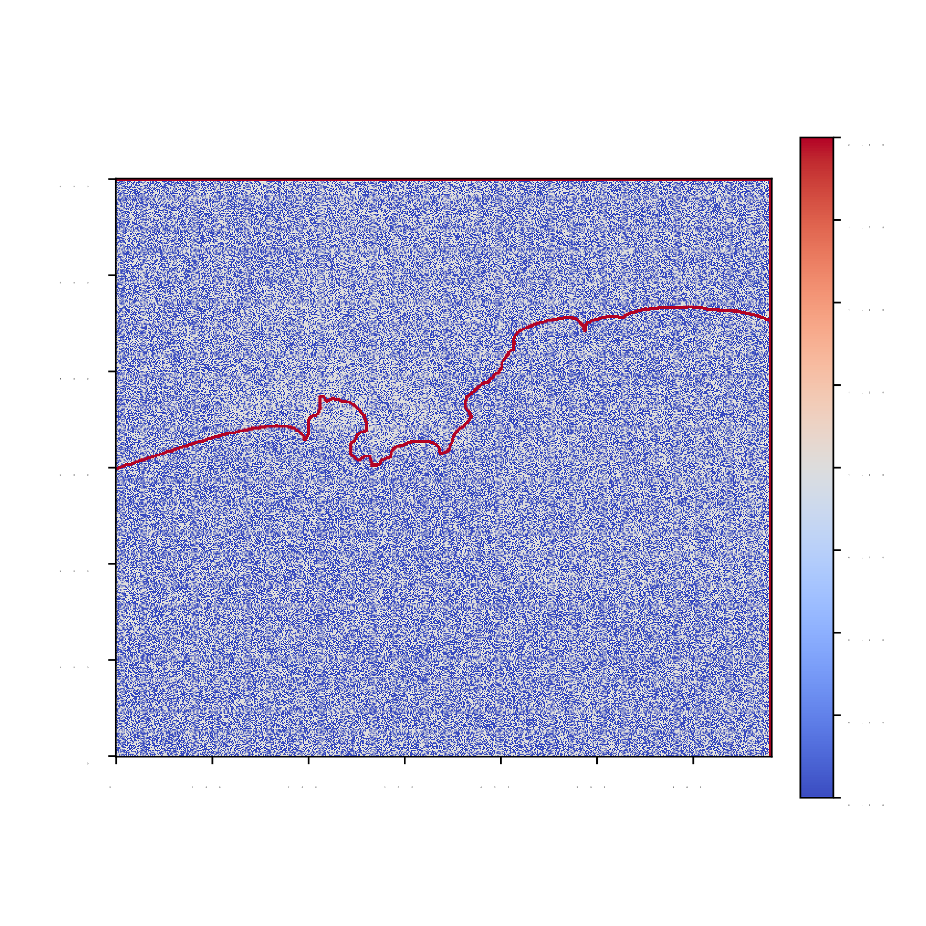
SIM-D²NN (No phase rotation)

SIM-D²NN (Baseline)
Digital DNN
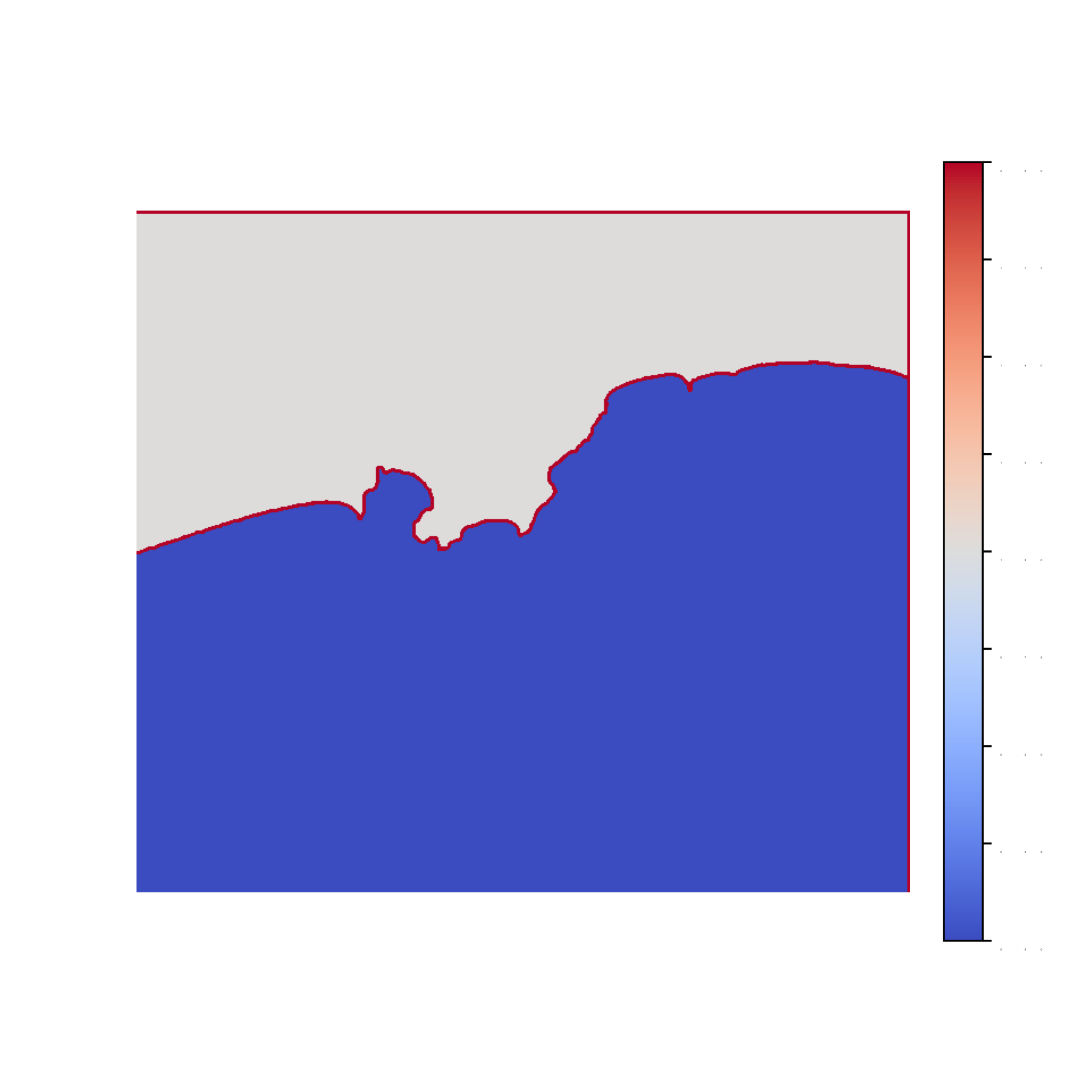
Ground Truth Label
Comparison of the visualization results under different methods.
Conclusion
We have developed a multi-layer, SIM-D²NN designed to process S1 raw IQ data for terrain classification. By harnessing the inherent properties of wave propagation through multiple metasurface layers, this approach has demonstrated the ability to achieve as high a performance as around 90%. This significant performance boost reduces dependence on digital processing backends and lowers the costs associated with data transmission. These encouraging outcomes underscore the potential of wave-domain analog computing to revolutionize remote sensing technologies, offering faster, more efficient, and sustainable solutions for Earth observation.
Acknowledgments
This research received funding from the Agency for Science, Technology and Research (A*STAR), Singapore, under Grant No. M22L1b0110. It was also supported by the National Research Foundation, Singapore, and the Infocomm Media Development Authority under the Future Communications Research & Development Programme (FCP-NTU-RG-2024-025).
Citation
If you find this work useful for your research, please consider citing:
@article{liu2025onboard,
  title={Onboard Terrain Classification via Stacked Intelligent Metasurface-Diffractive Deep Neural Networks from SAR Level-0 Raw Data},
  author={Liu, Mengbing and Li, Xin and An, Jiancheng and Yuen, Chau},
  journal={ICLR ML4RS Workshop},
  year={2025}
}
Copied!